Back Тыргартэн Byelorussian Tiergarten Breton Tiergarten Catalan Tiergarten (bahin nga lungsod) CEB Tiergarten Danish Berlin-Tiergarten German Τίργκαρτεν Greek Tiergarten Esperanto Tiergarten Basque تیرگارتن (برلین) Persian
Tiergarten | |
|---|---|
 Panoramic view of the southern part of Tiergarten | |
| Coordinates: 52°31′00″N 13°22′00″E / 52.51667°N 13.36667°E | |
| Country | Germany |
| State | Berlin |
| City | Berlin |
| Borough | Mitte |
| Founded | 1861 |
| Area | |
• Total | 5.17 km2 (2.00 sq mi) |
| Elevation | 52 m (171 ft) |
| Population (2023-12-31)[1] | |
• Total | 16,313 |
| • Density | 3,200/km2 (8,200/sq mi) |
| Time zone | UTC+01:00 (CET) |
| • Summer (DST) | UTC+02:00 (CEST) |
| Postal codes | 10557, 10785, 10787 |
| Vehicle registration | B |
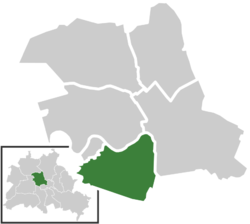
Tiergarten (German: [ˈtiːɐ̯ˌɡaʁtn̩] ⓘ, literally Animal Garden, historically meaning deer park or hunting game park[2]) is a locality within the borough of Mitte, in central Berlin (Germany). Notable for the great and homonymous urban park, before German reunification, it was a part of West Berlin. Until Berlin's 2001 administrative reform, Tiergarten was also the name of a borough (Bezirk), consisting of the current locality (Ortsteil) of Tiergarten (formerly called Tiergarten-Süd) plus Hansaviertel and Moabit. A new system of road and rail tunnels runs under the park towards Berlin's main station in nearby Moabit.
- ^ "Einwohnerinnen und Einwohner im Land Berlin am 31. Dezember 2023". Amt für Statistik Berlin-Brandenburg. February 2024.
- ^ As still recalled in Tiergarten's coat of arms the meaning of 'Tier' used to be narrower in history than in modern German, originally describing 'game', i.e. non-domesticated animals hunted, and among them preferently the deer.


